Envisioning Hudson Square
New York, NY, 2007
New York, NY, 2007
The Commissioner’s Plan of 1811 established the grid as the principal ordering mechanism for the speculative territory of Manhattan. Where this system breaks down, pathologies develop in the local urban tissue, and the social vigor that typifies New York street life is subject to retardation and stagnation.
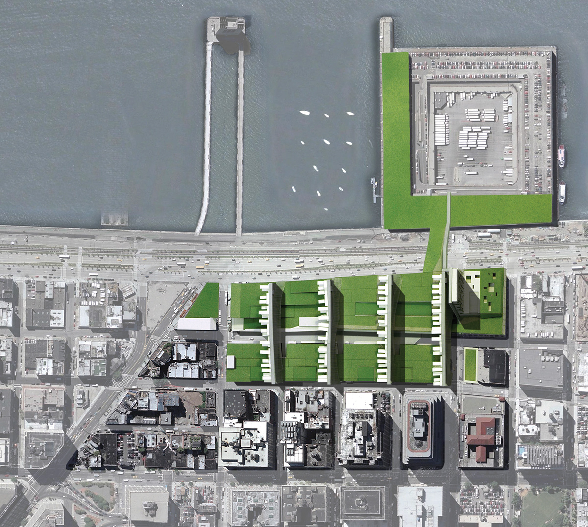
This proposal for the Hudson Square district contends with precisely such a disruption in the Manhattan grid. While the site is relatively porous along its northern and eastern edges, the grid in Hudson Square is interrupted by two multiblock structures: the UPS facility and St. John’s Center. Together the two buildings produce a massive obstacle to east-west movement and sever any meaningful connection to the river and the park. Recognizing that these two monoliths are likely to remain for economic and logistical reasons, this project reimagines and exploits these apparent impediments to the vitality of an emerging neighborhood in order to produce a new form of metropolitan sectional density. A series of stacked and interconnected layers combine housing, park space, and commercial and retail activity in a dynamic mix. The proposal asks: can the very idiosyncrasies of these anomalous structures sponsor an unprecedented urbanism that reconciles the logic of the grid with the expansive territory of the superblocks?
This proposal for the Hudson Square district contends with precisely such a disruption in the Manhattan grid. While the site is relatively porous along its northern and eastern edges, the grid in Hudson Square is interrupted by two multiblock structures: the UPS facility and St. John’s Center. Together the two buildings produce a massive obstacle to east-west movement and sever any meaningful connection to the river and the park. Recognizing that these two monoliths are likely to remain for economic and logistical reasons, this project reimagines and exploits these apparent impediments to the vitality of an emerging neighborhood in order to produce a new form of metropolitan sectional density. A series of stacked and interconnected layers combine housing, park space, and commercial and retail activity in a dynamic mix. The proposal asks: can the very idiosyncrasies of these anomalous structures sponsor an unprecedented urbanism that reconciles the logic of the grid with the expansive territory of the superblocks?
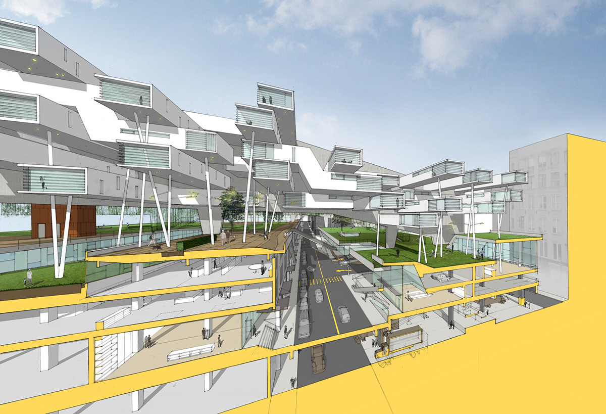
The cross section reveals the multilayered vertical urbanism generated by the superimposition of grid and superblock. Above, a series of housing units are arrayed to optimize southern exposures and riverfront views; they are linked by an elevated sidewalk that extends the east-west grid over the roofs of the superblocks. Below, the former rooftops function as a new public lawn and a series of community gardens. Voids within this elevated landscape allow for the penetration of daylight into the deep floor plates of the historic facilities, enabling more efficient utilization and improved environmental quality.

Conceptual Diagrams: Site, Raise Washington Street, Green the superblock, Extend the sidewalk

Conceived as elevated extensions of the east-west sidewalks, the ramping walkways that access the housing are suspended between screens of vertical steel cables and structural walls of concrete. While the screens allow the park’s growth to climb upward, forming a series of porous green membranes to the north, the solid walls provide a unifying facade for the housing to the south and function as deep beams to span the superblocks below. The northernmost housing bar slices through St. John’s Center at the intersection of Houston Street, visually opening this major urban axis to Hudson River Park and reaching across the West Side Highway to Pier 40. The north end of St. John’s Center is developed as a twelve-story hotel.
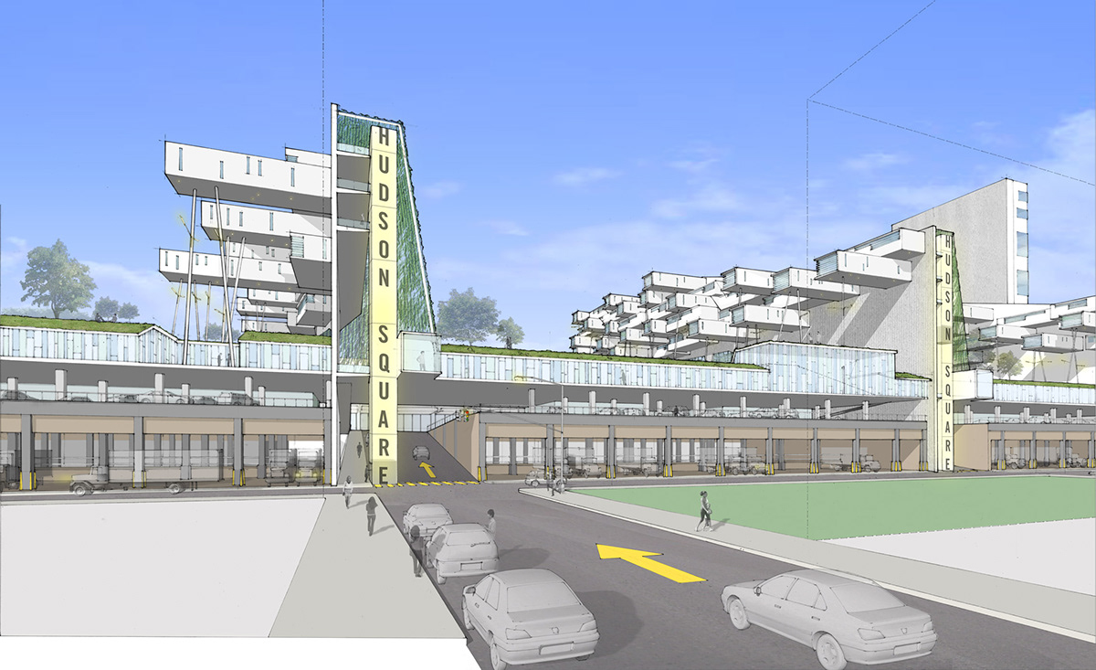
Sloped extensions of the existing historic street grid connect the old neighborhood to the elevated shopping street and raised green space. The existing UPS distribution facility continues to function at ground level, providing a vital service to the economy of the city.
Aerial view
Project Credits
Envisioning Hudson Square, 2007, New York, NY
Client: Friends of the Highline
Project team: Paul Lewis, Marc Tsurumaki, David J. Lewis; Clark Manning, Jason Dannenbring, Diana Martinez, Laura Cheung, Mia Lorenzetti
Curators: Michael Kramer, Stella Kramer
Envisioning Hudson Square, 2007, New York, NY
Client: Friends of the Highline
Project team: Paul Lewis, Marc Tsurumaki, David J. Lewis; Clark Manning, Jason Dannenbring, Diana Martinez, Laura Cheung, Mia Lorenzetti
Curators: Michael Kramer, Stella Kramer

